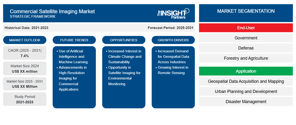
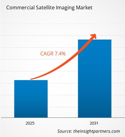
The Commerical Satelite Imaging Market is expected to register a CAGR of 7.4% from 2025 to 2031, with a market size expanding from US$ XX million in 2024 to US$ XX Million by 2031.
The report is segmented by End-User (Government, Defense, Forestry and Agriculture, Energy, Civil Engineering and Archaeology, Commercial Enterprises, Others); Application (Geospatial Data Acquisition and Mapping, Urban Planning and Development, Disaster Management, Energy and Natural Resource Management, Surveillance and Security, Others). The global analysis is further broken-down at regional level and major countries. The Report Offers the Value in USD for the above analysis and segments.
Purpose of the Report
The report Commerical Satelite Imaging Market by The Insight Partners aims to describe the present landscape and future growth, top driving factors, challenges, and opportunities. This will provide insights to various business stakeholders, such as:
- Technology Providers/Manufacturers: To understand the evolving market dynamics and know the potential growth opportunities, enabling them to make informed strategic decisions.
- Investors: To conduct a comprehensive trend analysis regarding the market growth rate, market financial projections, and opportunities that exist across the value chain.
- Regulatory bodies: To regulate policies and police activities in the market with the aim of minimizing abuse, preserving investor trust and confidence, and upholding the integrity and stability of the market.
Commerical Satelite Imaging Market Segmentation
End-User
- Government
- Defense
- Forestry and Agriculture
- Energy
- Civil Engineering and Archaeology
- Commercial Enterprises
- Others
Application
- Geospatial Data Acquisition and Mapping
- Urban Planning and Development
- Disaster Management
- Energy and Natural Resource Management
- Surveillance and Security
- Others
Customize This Report To Suit Your Requirement
You will get customization on any report - free of charge - including parts of this report, or country-level analysis, Excel Data pack, as well as avail great offers and discounts for start-ups & universities
Commercial Satellite Imaging Market: Strategic Insights
- Get Top Key Market Trends of this report.This FREE sample will include data analysis, ranging from market trends to estimates and forecasts.
Commerical Satelite Imaging Market Growth Drivers
- Increased Demand for Geospatial Data Across Industries: Farmers use satellite imagery in monitoring crop health, detecting soil conditions, and forecast yields, hence more suitable decision-making and sustainable practice. Cities' planners and architects benefit from satellite data in land-use maps, urban expansion analysis, as well as infrastructure development. For them, it becomes more possible to trace changes about the environment, track down construction progress, and even pattern traffic flow.
- Growing Interest in Remote Sensing: The ability to monitor vast areas with minimal human intervention makes satellite imaging especially attractive for applications like agriculture, forestry, oceanography, and mining. Remote sensing technology offers detailed insights into the Earth's surface and atmosphere.
Commerical Satelite Imaging Market Future Trends
- Use of Artificial Intelligence and Machine Learning: AI and machine learning algorithms are now increasingly used to analyze satellite images, which can be used to identify patterns and predict trends in ways that would be difficult for a human alone. This adds another layer of value to satellite data, allowing industries to extract more actionable insights.
- Advancements in High-Resolution Imaging for Commercial Applications: A major future trend in the commercial satellite imaging market is the development of ultra-high-resolution imaging capabilities. As satellite technology improves, the ability to capture more detailed, precise images will enhance applications in industries like agriculture, disaster management, urban planning, and infrastructure monitoring. This will drive increased demand for high-resolution satellite imagery to support data-driven decision-making and advanced analytics across various sectors.
Commerical Satelite Imaging Market Opportunities
- Increased Interest in Climate Change and Sustainability : As global interest in climate change continues to escalate, demand for satellite images of changing conditions in the environment, from rising sea levels to loss of forests to melting ice caps, has similarly increased. Satellite imaging can help organizations manage their carbon footprint, maintain a supply chain, and monitor the ways in which land is being used while working towards sustainable goals.
- Opportunity in Satellite Imaging for Environmental Monitoring: The growing demand for environmental monitoring presents a significant opportunity in the commercial satellite imaging market. Satellite technology can provide critical data on climate change, deforestation, pollution levels, and natural disaster impact. As governments and organizations focus on sustainability, there is a rising need for accurate, real-time satellite imagery to inform policy decisions and enhance environmental protection efforts, creating a valuable market opportunity.
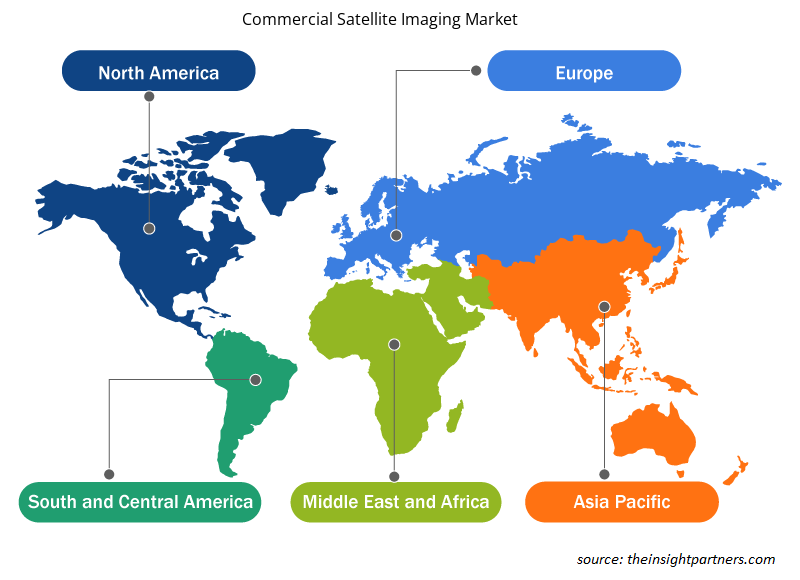
Commercial Satellite Imaging Market Regional Insights
The regional trends and factors influencing the Commercial Satellite Imaging Market throughout the forecast period have been thoroughly explained by the analysts at Insight Partners. This section also discusses Commercial Satellite Imaging Market segments and geography across North America, Europe, Asia Pacific, Middle East and Africa, and South and Central America.
- Get the Regional Specific Data for Commercial Satellite Imaging Market
Commercial Satellite Imaging Market Report Scope
| Report Attribute | Details |
|---|---|
| Market size in 2024 | US$ XX million |
| Market Size by 2031 | US$ XX Million |
| Global CAGR (2025 - 2031) | 7.4% |
| Historical Data | 2021-2023 |
| Forecast period | 2025-2031 |
| Segments Covered |
By End-User
|
| Regions and Countries Covered | North America
|
| Market leaders and key company profiles |
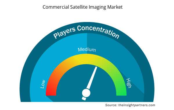
Commercial Satellite Imaging Market Players Density: Understanding Its Impact on Business Dynamics
The Commercial Satellite Imaging Market market is growing rapidly, driven by increasing end-user demand due to factors such as evolving consumer preferences, technological advancements, and greater awareness of the product's benefits. As demand rises, businesses are expanding their offerings, innovating to meet consumer needs, and capitalizing on emerging trends, which further fuels market growth.
Market players density refers to the distribution of firms or companies operating within a particular market or industry. It indicates how many competitors (market players) are present in a given market space relative to its size or total market value.
Major Companies operating in the Commercial Satellite Imaging Market are:
- Spaceflight Industries, Inc.
- Galileo Group, Inc.
- ImageSat International N.V.
- Maxar Technologies, Inc.
- Planet Labs, Inc.
Disclaimer: The companies listed above are not ranked in any particular order.
- Get the Commercial Satellite Imaging Market top key players overview
Key Selling Points
- Comprehensive Coverage: The report comprehensively covers the analysis of products, services, types, and end users of the Commerical Satelite Imaging Market, providing a holistic landscape.
- Expert Analysis: The report is compiled based on the in-depth understanding of industry experts and analysts.
- Up-to-date Information: The report assures business relevance due to its coverage of recent information and data trends.
- Customization Options: This report can be customized to cater to specific client requirements and suit the business strategies aptly.
The research report on the Commerical Satelite Imaging Market can, therefore, help spearhead the trail of decoding and understanding the industry scenario and growth prospects. Although there can be a few valid concerns, the overall benefits of this report tend to outweigh the disadvantages.
- Historical Analysis (2 Years), Base Year, Forecast (7 Years) with CAGR
- PEST and SWOT Analysis
- Market Size Value / Volume - Global, Regional, Country
- Industry and Competitive Landscape
- Excel Dataset
- Radiopharmaceuticals Market
- Cosmetic Bioactive Ingredients Market
- Terahertz Technology Market
- Europe Industrial Chillers Market
- Travel Vaccines Market
- Gas Engine Market
- Advanced Planning and Scheduling Software Market
- Data Annotation Tools Market
- Railway Braking System Market
- Nitrogenous Fertilizer Market

Report Coverage
Revenue forecast, Company Analysis, Industry landscape, Growth factors, and Trends

Segment Covered
This text is related
to segments covered.

Regional Scope
North America, Europe, Asia Pacific, Middle East & Africa, South & Central America

Country Scope
This text is related
to country scope.
Frequently Asked Questions
Some of the customization options available based on the request are an additional 3-5 company profiles and country-specific analysis of 3-5 countries of your choice. Customizations are to be requested/discussed before making final order confirmation# as our team would review the same and check the feasibility
The report can be delivered in PDF/PPT format; we can also share excel dataset based on the request
The Commerical Satelite Imaging Market is estimated to witness a CAGR of 7.4% from 2023 to 2031
The use of Artificial Intelligence and Machine Learning is anticipated to play a significant role in the global Commerical Satelite Imaging market in the coming years
The major factors driving the Commerical Satelite Imaging market are Increased Demand for Geospatial Data Across Industries and Growing Interest in Remote Sensing.
Trends and growth analysis reports related to Aerospace and Defense : READ MORE..
1.Spaceflight Industries, Inc.
2.Galileo Group, Inc.
3.ImageSat International N.V.
4.Maxar Technologies, Inc.
5.Planet Labs, Inc.
6.UrtheCast Corporation
7.Airbus SE
8.Saab Group (Vricon, Inc.)
9.Trimble, Inc.
10.L3Harris Technologies, Inc.
 Get Free Sample For